Cougar Creek Fire tops 8,000 acres; evacuation warning remains in place
Published 1:00 pm Monday, July 22, 2024
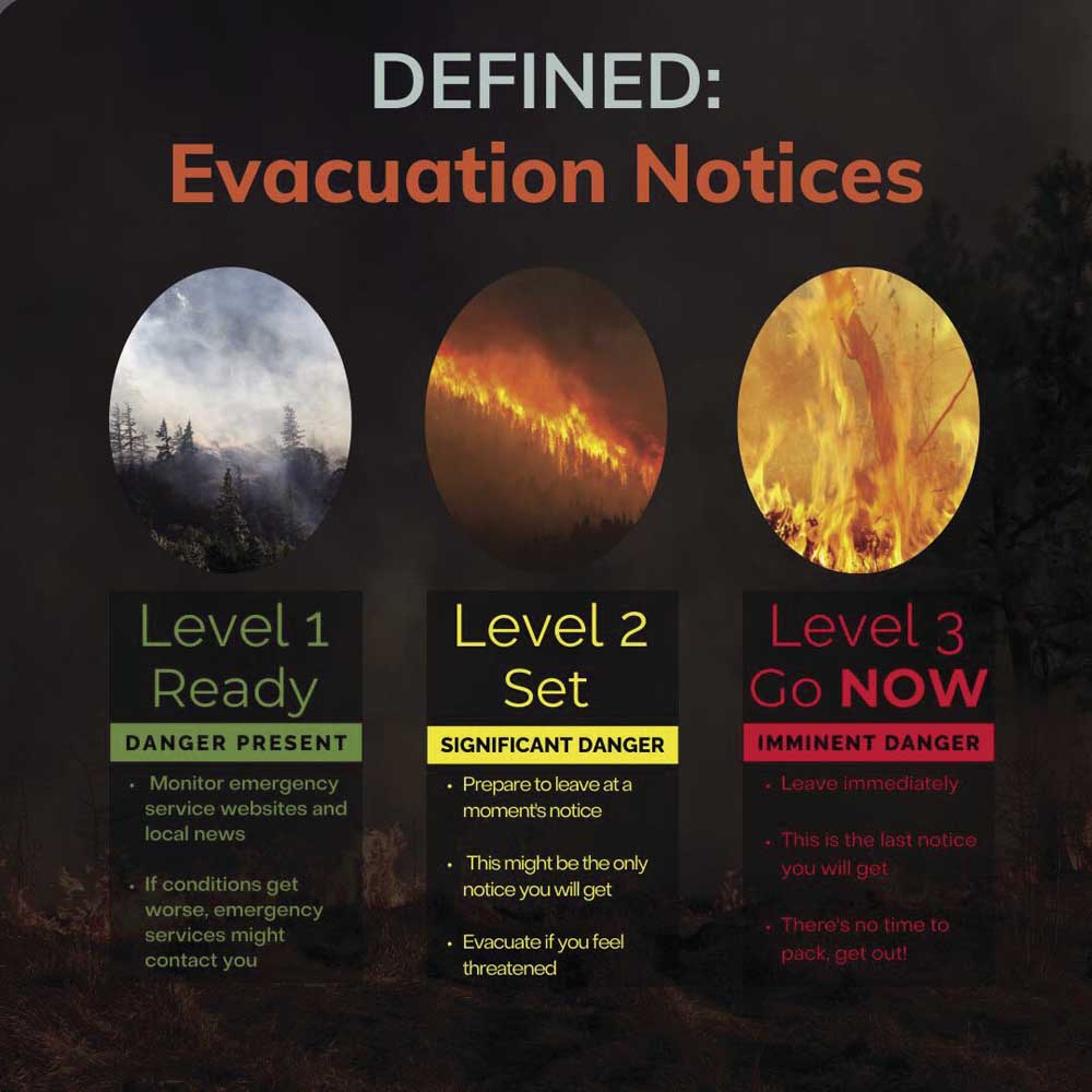
- 3fire evac.jpg
TROY — The Cougar Creek Fire had increased to 8,271 acres by Monday morning, July 22, but had yet to cross the Grande Ronde River into Oregon, the Washington Department of Natural Resources reported.
The fire is now 23% contained, according to a spokeswoman for the Garfield County (Washington) Sheriff’s Office.
“The river itself is their strongest line,” she said.
The Wallowa County Sheriff’s Office has issued a Level 2 evacuation notice for the Grouse Flat area, north of the Grande Ronde to the state and Garfield County lines. Level 2 is “be set,” meaning that residents should be ready to leave at a moment’s notice.
The Level 2 area includes Grouse Flat from Bear Creek north. The Grande Ronde River Road from Troy to the Washington state line has been closed since Wednesday, July 17, when the Wallowa County Board of Commissioners ordered the closure.
A spot fire detected Sunday has progressed into the West Fork of the Wenatchee Creek drainage and is moving toward Grouse Flat, where crews are working on protection efforts. Structure protection tactics are in place.
A helibase was established in Anatone, Washington, for better flight access to the fire area. Perimeter progression is expected to continue over the next few days due to limited access and extreme weather conditions.
The Washington Department of Natural Resources said the fire, burning about 35 miles southwest of Dayton, Washington, is expected to progress uphill from the Wenatchee drainage and is heavily influenced by critical fire weather conditions, topography and fuel loading. An excessive heat warning remains in effect through 10 a.m. Monday. There is a small chance (less than 10%) of thunderstorms in the area, with lightning and wind gusts being concerns. Hot conditions will continue, but elevated relative humidity could reduce overall fire behavior.
The Northwest Incident Management Team in charge of controlling the blaze said that an unmanned aircraft system is being used in the fire area to assist firefighters with infrared and mapping.
Air operations continue to drop retardant and water to limit the progression of the fire and to secure the area around Grouse Flat. Additional air resources were diverted to support firefighting efforts as activity increased Sunday afternoon. Morning smoke has generated visibility challenges, limiting aircraft availability.
The Oregon Department of Environmental Quality issued an air quality advisory Monday for several counties in Eastern Oregon. Wallowa County was not on the advisory list, but several of its neighbors were and haze and smoke were visible throughout the county on Monday.
Smoke will continue to be moderate across the area near Troy, Anatone, and Clarkston for the next few days. People who are unusually sensitive to particle pollution may consider reducing their activity levels or shortening the amount of time they’re active outdoors, health officials said. Current air conditions are available at the website AirNow.gov.
The cause of the fire is yet to be determined. One residence has been destroyed, and 153 remained threatened, according to the Northwest Interagency Coordination Center. Three minor structures have been destroyed and five damaged, with 409 still threatened, the center said.