Prescribed fire spreads into Walla Walla’s watershed
Published 3:15 pm Monday, October 7, 2024
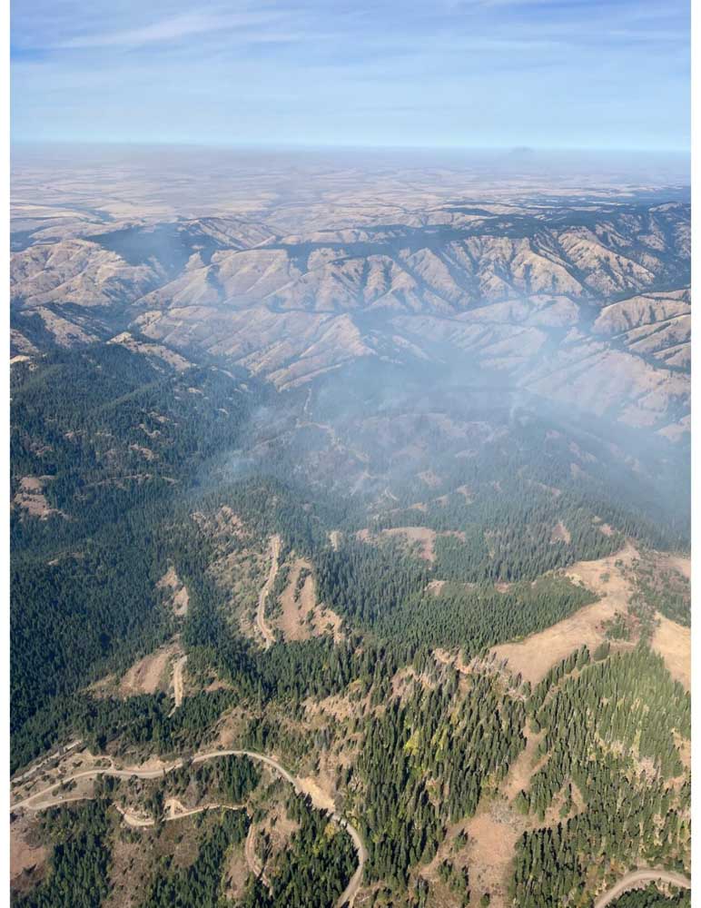
- The Tiger Creek prescribed fire burned beyond its perimeter and into the Mill Creek watershed on Oct. 1, 2024, about 13 miles east of Walla Walla.
WALLA WALLA — A prescribed fire intended to help protect the source of Walla Walla’s drinking water from wildfires spread into the watershed on Oct. 1 as the weather turned drier and windier than Forest Service fire managers expected.
But officials from the Umatilla National Forest, which manages the Mill Creek watershed in the northern Blue Mountains, said the flames have mainly stayed on the ground and had the beneficial effects that prompted the Tiger Creek prescribed fire.
Trending
There was “minimal” torching of tree canopies when the fire initially burned into the watershed, Brett Thomas, the Umatilla’s fire management officer, said Oct. 3.
That remained the case after the fire grew to an estimated 593 acres as of Tuesday, Oct. 8, said Johnny Collin, Walla Walla District ranger.
“Based on current observations, the fire effects of the additional acres burned over the weekend were similar to what had occurred prior to the weekend within the watershed,” Collin said. “However, we will not know for sure until we can evaluate the area after the fire has been fully suppressed.”
Adrian Sutor, water operations manager for Walla Walla, said he is not concerned about the effects of the fire.
In fact, Sutor said city officials supported plans to light prescribed fires in much of the 23,000-acre watershed in the future, with a goal of reducing the fuel load and the risk of a large wildfire that could pollute the drinking water.
“The prescribed burn is getting done earlier than we thought,” Sutor said on Tuesday, Oct. 8. “We really don’t have much concern.”
Trending
Sutor said the one potential issue, and he expects it will be small or nonexistent, is that water could be more turbid while snow is melting next spring.
The prescribed fire, which forest officials designated as a wildfire about 3 p.m. on Oct. 1, was supposed to cover about 335 acres. Of the 593 acres burned as of Oct. 8, about 475 acres are within the watershed, according to the Umatilla National Forest.
Umatilla National Forest officials summoned air tankers and helicopters to drop water on the fire to try to prevent it from spreading farther.
An overhead team took over the firefighting effort on Oct. 4.
Public access is restricted in the area, where the deer hunting season started Oct. 5.
From prescribed fire to wildfire
Fire crews ignited the blaze around 11 a.m. on Sept. 30, Collin said.
It was the second prescribed fire adjacent to the Mill Creek watershed. The first, in early October 2022, burned about 160 acres.
The goal for both the 2022 fire and this year’s blaze is to reduce the amount of fuel on the ground near the watershed, Collin said.
Forest officials say prescribed fires can reduce the risk of wildfires.
As the source of drinking water for tens of thousands of people, the watershed is a “critical area,” Collin said, and reducing the wildfire risk is a priority.
The conditions conducive to a prescribed fire in the area typically are fleeting, however, Collin said.
The first significant fall rainstorm can leave the ground too sodden to carry the flames that reduce the fuel load, he said.
“We look for opportunities” to use prescribed fire to pare the fuel load, Collin said, “and at the time we lit this fire we had those conditions and the conditions in the forecast.”
But the weather didn’t follow that script, Thomas said.
Overnight from Sept. 30 to Oct. 1, the relative humidity — how much moisture is in the air — did not increase to the forecast level of around 65%, Thomas said.
The maximum humidity that night, measured by a Corps of Engineers weather station about a mile away, was around 40%, he said.
“That made quite a difference” in the fire behavior, Thomas said.
The typical increase in humidity during the night — what fire managers call “humidity recovery” — can have a significant effect on fires, with the additional moisture in the air temporarily slowing a fire’s spread.
But the unexpectedly low humidity wasn’t the only factor that contributed to the Tiger Creek prescribed fire’s spread.
Thomas said winds on Oct. 1 also were stronger than forecast, with gusts around 20 mph.
A forecast discussion posted on the website for the National Weather Service’s Pendleton office at 10:06 a.m. on Sept. 30, the day the prescribed fire was ignited, called for “light winds.” A discussion posted at 1:58 p.m. that day stated that humidity and winds likely wouldn’t reach a “critical fire weather threshold.”
With the combination of low humidities and stronger-than-forecast winds, fire managers decided on the morning of Oct. 1 not to ignite any additional acres, as had been planned, Collin said.
Instead, forest employees sought to keep the fire within its planned perimeter.
Given the conditions, that was “challenging,” Thomas said.
“This is difficult country to burn in,” Collin said during a public meeting at Walla Walla High School on Oct. 4.
In response to questions from the audience, Collin said forest officials “will learn from this” and use the fire to refine the criteria they use to decide whether to light prescribed fires.
After officials declared the blaze a wildfire on Oct. 1, three heavy helicopters, along with two fixed-wing aircraft, dropped water on the fire to help fire crews on the ground.
The weather also cooperated, Thomas said, with the humidity rising to about 65% on the morning of Oct. 2.
But with a return to warmer, drier weather over the weekend, the Tiger Creek Fire grew again, from an estimated 383 acres on Oct. 3 to 475 acres on Oct. 5 and to 593 acres on Oct. 7.
“Poor overnight relative humidity recoveries in the mid-elevations continue to plague firefighting efforts exacerbated by lower-than-normal relative humidity during the day,” according to the Oct. 7 update from the management team.
A total of 487 people were assigned to the fire on Oct. 8. The blaze was 7% contained.
Closures and restrictions
Forest Road 65 is closed to the junction with Indian Camp.
Government Mountain Road, No. 6511, is closed from the North Fork Walla Walla trailhead to the junction with Road 65 at Tiger Saddle. Road 6511 is open from the west to the North Fork Walla Walla trailhead.
More information regarding restrictions is available by calling the Umatilla National Forest’s toll-free hotline at 877-958-9663.
Marketplace


-
eEdition

-

-
