Weather slows Cougar Creek blaze, but hot and dry conditions set to return
Published 10:27 am Wednesday, July 31, 2024
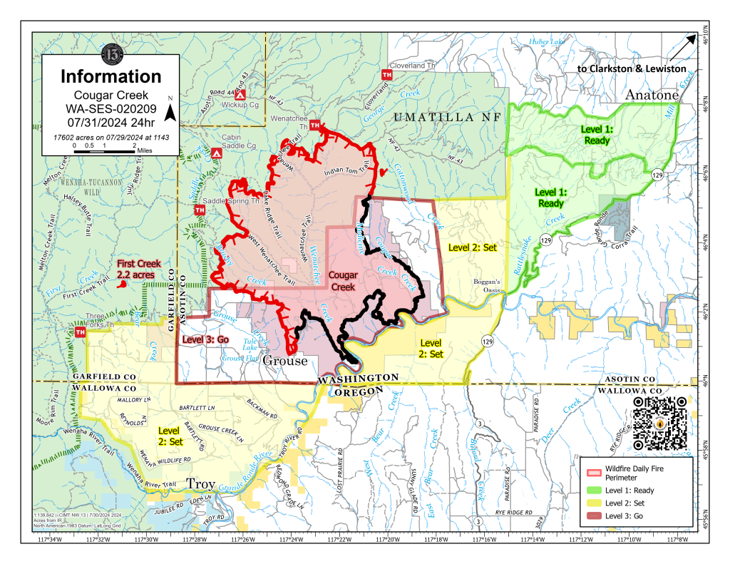
- This map shows current boundaries of the Cougar Creek Fire as of Wednesday, July 31. Areas that remain under some sort of evacuation notice also are shown on the map.
TROY — Recent rains and higher humidity levels slowed fire activity Tuesday, July 30 on the Cougar Creek Fire, but fire officials are keeping a wary eye on forecasts calling for hotter and drier conditions as the week progresses.
In their Wednesday update on the fire, burning just north of the Washington state line, officials said lower temperatures and higher relative humidity levels over the last few days have meant that fire progression has been primarily driven by terrain. But a high pressure system is expected to bring warmer temperatures beginning Friday, and as the mercury climbs back into the triple digits, fire behavior may increase.
In the meantime, firefighters resumed tactical burning operations on the southwest side of the fire on Tuesday to secure a portion of the perimeter. The secondary line on Mallory Ridge east of the fire is nearing completion.
The First Creek Fire, from last week’s lightning storm, continues to be monitored for smoke and is contained west of the main fire. A spot fire on the eastern edge of the Cougar Creek Fire is controlled and being monitored for hot spots, the update reported.
On the southwest flank of the fire near Grouse Flat, crews have begun patrolling and monitoring the perimeter. If smoke is detected, initial attack crews will respond. Tactical firing operations will take place as weather conditions allow on the 600 Road and Hansen Ridge.
Complex Incident Management Team Northwest 13 will transfer command of the fire to Complex Incident Management Team Northwest 12, under the direction of Incident Commander Jeff Dimke, Wednesday at 7 p.m.
The fire is estimated at 17,602 acres and is 29% contained. Total containment is still estimated to occur around Oct. 1. In all, 595 firefighters are assigned to the fire.
A section of northern Wallowa County remains under a Level 2 evacuation, in which residents are urged to be ready to evacuate at a moment’s notice. The area includes all of Grouse Flat from Bear Creek north to state and county lines all the way to the Grande Ronde River. The Grande Ronde Road is closed to Troy to the Highway 129 junction in Washington. Information on Wallowa County evacuation notices can be found on the Wallowa County Sheriff’s Office Facebook page.
Various areas in Washington state’s Asotin and Garfield counties also are under some level of evacuation notice. Information on those can be found on the Asotin County Sheriff’s Office Facebook page and the Garfield County Emergency Management Facebook page.
For information about the fire, go to the Cougar Creek Fire Facebook page.