Lines holding as growth slows on Cougar Creek fire
Published 11:05 am Saturday, July 27, 2024
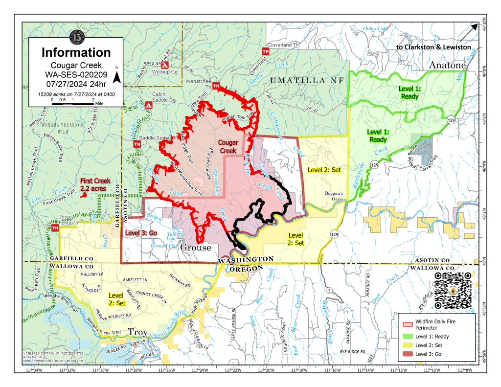
- This map of the Cougar Creek Fire shows the fire's boundaries and areas under evacuation notices as of Saturday, July 27, 2024.
Lines are holding on the Cougar Creek Fire burning just north of the Washington state line and the growth of the blaze has slowed, according to an update on the fire issued Saturday, July 27.
The fire, burning about 35 miles southwest of Dayton, Washington, has grown to 15,209 acres and remains 26% contained. It was first reported on July 15. The cause of the fire remains under investigation.
The Saturday morning update from fire officials said all primary lines on the fire continue to hold, and indirect lines still are being developed on the western flank of the fire. (Indirect lines involve building control lines some distance away from the main fine edge and burning out the intervening fuel.)
The fire is advancing to the west, into national forest land, at a rate of one-tenth to one-quarter of an acre per day.
On the east flank of the fire, crews are mopping up from the fire’s edge into the black in order to find hotspots and secure against future reignition. No progression was reported on the fire’s southern flank.
Night operations continue, as officials monitor weather conditions and evaluate burning options to connect containment lines.
Efforts to protect structures remain a primary focus in the Grouse Flat area. The fire has destroyed one residence and still threatens 153. Three minor structures have been destroyed and five more damaged; 409 minor structures are threatened.
A new lightning strike was detected Friday about 3 miles west from the fire. A helicopter scouted the area and confirmed the location of the start. It then conducted five water drops as rappellers directly engaged the fire in steep, rough terrain.
A drone was used to detect heat signatures below the smoke layer in the valleys, which provided more accurate mapping capabilities.
Firefighters were then better able to plan and carry out supersession operations.
Winds are expected to shift Saturday evening and will come from the west. Humidity levels remain below average levels. There is a chance of thunderstorms early next week, followed by an increase in temperatures and drying trends.
In all, 643 firefighters are working on the fire.
A section of northern Wallowa County remains under a Level 2 evacuation, in which residents are urged to be ready to evacuate at a moment’s notice. The area includes all of Grouse Flat from Bear Creek north to state and county lines all the way to the Grande Ronde River. The Grande Ronde Road is closed to Troy to the Highway 129 junction in Washington. Information on Wallowa County evacuation notices can be found on the Wallowa County Sheriff’s Office Facebook page.
Various areas in Washington state’s Asotin and Garfield counties also are under some level of evacuation notice. Information on those can be found on the Asotin County Sheriff’s Office Facebook page and the Garfield County Emergency Management Facebook page.
For information about the fire, go to the Cougar Creek Fire Facebook page.