Crews make progress on Cougar Creek fire, now at 14,778 acres
Published 10:44 am Friday, July 26, 2024
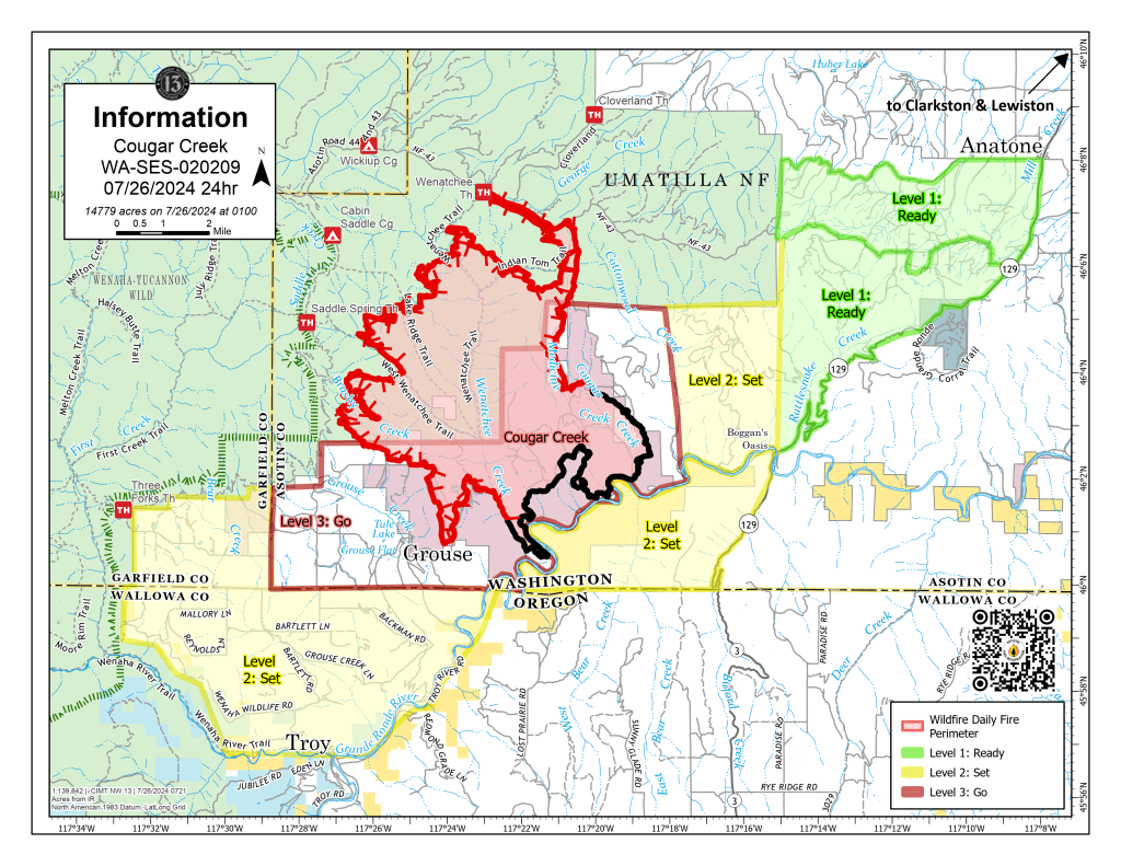
- The July 26, 2024 Cougar Creek Fire map shows the fire's boundaries and areas that remain under evacuation warnings.
Firefighters continue to make progress on the Cougar Creek Fire burning just north of the Washington state line, according to an update on the fire issued Friday, July 26.
The fire, burning about 35 miles southwest of Dayton, Washington, has grown to 14,778 acres and is 26% contained. It was first reported on July 15.
Air operations continued Thursday and assisted in securing the perimeter. Washington Department of Natural Resources crews were able to successfully build line around and then mop up a fire near Anatone which was caused by a lightning strike.
On the southwest side of the fire, Grouse Flat remains a priority to protect property, the update said.
In the Wenatchee Creek drainage, fire crews are working to secure and tie in control lines to the contained flank of the fire. This will free up resources to reengage fire suppression operations on the west flank, where firefighters continue to build indirect line. (Indirect lines involve building control lines some distance away from the main fine edge and burning out the intervening fuel.)
After a successful tactical ignition on the east flank of the fire north of the contained Hanson Ridge area, crews are checking for smoke and hotspots and enhancing direct line construction.
Ridgetop winds are expected to be lighter on Friday and to switch back to the southeast. A slight warming trend is still in the forecast for the weekend, along with a chance of thunderstorms again for early next week.
Fuels will remain exceptionally dry, conditions that will support active fire spread to the north and west areas of the fire.
To date, the fire has destroyed one residence and threatens 153. Three minor structures have been destroyed by the fire and five more damaged: 409 minor structures are threatened.
In all, 582 firefighters are battling the blaze.
A section of northern Wallowa County remains under a Level 2 evacuation, in which residents are urged to be ready to evacuate at a moment’s notice. The area includes all of Grouse Flat from Bear Creek north to state and county lines all the way to the Grande Ronde River. The Grande Ronde Road is closed to Troy to the Highway 129 junction in Washington.
Various areas in Washington state’s Asotin and Garfield counties also are under some level of evacuation notice. Information on those can be found on the Asotin County Sheriff’s Office Facebook page and the Garfield County Emergency Management Facebook page.
For information about the fire, go to the Cougar Creek Fire Facebook page.


-
eEdition

-

-