Eagle Cap Wilderness fires grow
Published 1:00 pm Wednesday, August 31, 2022
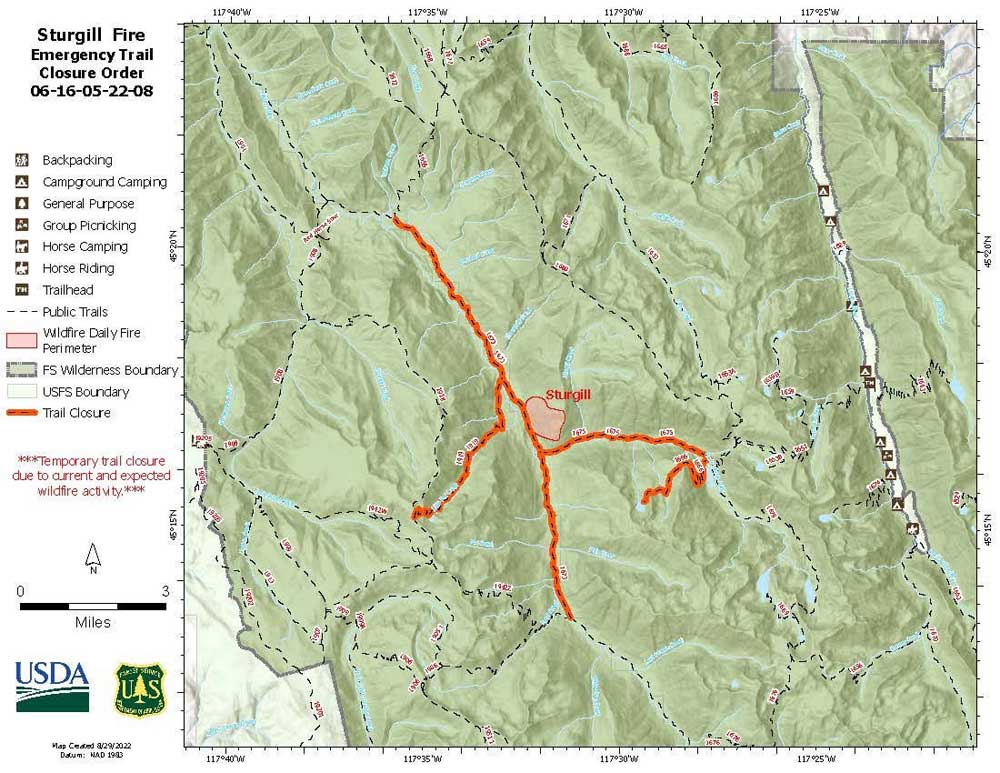
- Map shows trails that are closed near the Sturgill fire in the Eagle Cap Wilderness.
BAKER CITY — The Wallowa-Whitman National Forest has closed sections of three trails that are near one of the two growing lightning-sparked fires the agency is monitoring, but not fighting, in the Eagle Cap Wilderness.
The Wallowa-Whitman announced the trail closures, in the North Minam River area, on Tuesday, Aug. 30.
Both the Sturgill Fire, which is near the closed trails, and the Nebo Fire, more than 15 miles east across the wilderness, produced large smoke plumes on Aug. 30 as temperatures eclipsed record highs for the date.
The fires started Aug. 22.
The Sturgill Fire spawned a pyrocumulus cloud Aug. 30 — in effect, a thunderhead induced by the fire’s heat.
On Wednesday afternoon, Aug. 31, both the Sturgill and Nebo fires generated pyrocumulus clouds.
The atmosphere was already slightly unstable, meaning the sun was heating the ground and causing the air to rise high enough that some of the moisture condensed into cumulus clouds, said Jay Breidenbach, a meteorologist at the National Weather Service office in Boise.
The fire added considerably more heat to the equation, he said, allowing the air to rise even higher. The result was the pyrocumulus cloud.
Breidenbach said he reviewed a time-lapse loop of satellite images from Aug. 30, and the progression of both smoke from the Sturgill Fire, and the formation of the pyrocumulus cloud, were evident.
Such clouds typically form late in the afternoon and dissipate relatively rapidly after sundown as the air cools, Breidenbach said.
Sturgill Fire
The blaze, on the east side of the Minam River Canyon, is about 6 miles from the nearest private property.
Firefighters are working on a strategy to protect private land at Catherine Creek Meadow, to the southwest, and Red’s Horse Ranch and Minam River Lodge to the northwest.
The Wallowa-Whitman has closed sections of three trails near the fire.
• Minam River Trail, No. 1673, from the Bear Mountain Trail junction south to the Rock Creek Trail.
• North Minam Trail, No. 1675, from the Minam River Trail to the Bowman Trail.
• Green Lake Trail, No. 1666, from the North Minam Trail to Green Lake.
Nebo Fire
Firefighters are working along roads and trails outside the Eagle Cap Wilderness to potentially use them as control lines if necessary to protect the Lick Creek Guard Station, structures at Big Sheep Camp, and Indian Crossing campground along the Imnaha River should the fire threaten those, according to the Wallowa-Whitman.
There were no trail closures around the Nebo Fire as of Wednesday, Aug. 31.
Crockets Knob Fire
This blaze, started by lightning on Aug. 22, continues to burn on the Malheur National Forest, in the Greenhorn Mountains about 19 miles north of Prairie City.
The fire has burned about 1,900 acres. Gusty winds and higher temperatures on Tuesday, Aug. 30 resulted in active burning, and the fire produced a significant smoke column.
The fire has moved close to the west Princess Trailhead south of Indian Rock Lookout, and it has spread northeast onto a small part of the Umatilla National Forest.
Hot Shot crews are working on the east side of the fire, as well as in the roadless areas to the north and west, building and plotting containment lines.
On the southern flank, crews have blocked the fire in the Big Boulder Creek area.
Aircraft, including helicopters dipping water from Olive Lake to the north, continue to work on the fire.


-
eEdition

-

-