Storm leaves trail of damage, injuries in Wallowa
Published 11:27 pm Thursday, August 11, 2022
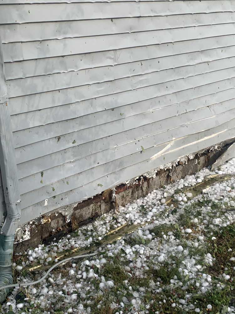
- A Wallowa home sustained significant damage to its exterior following a severe storm that rolled through Wallowa County on Thursday, Aug. 11, 2022. The storm produced tennis-ball-sized hail, according to the National Weather Service office in Pendleton.
WALLOWA — Bruce Eien said he remembers feeling a sense of deja vu Thursday, Aug. 11, in the aftermath of the severe storm that rolled through Wallowa County.
“It looked like how people were walking around after 9/11 — in a daze,” he said. “That’s exactly what it was.”
The Enterprise resident, who has family who live in Wallowa, where much of the damage from large hail was centered, was touring the county to look at the damage in the aftermath of the storm.
“We were driving around, checking on all of the people we knew,” he said, “making sure they were OK.”
Earlier in the day, the National Weather Service in Pendleton issued a severe thunderstorm warning for much of Wallowa County until 5 p.m. Aug. 11. The warning included 2-inch-sized hail and winds up to 50 mph. Camden Plunkett, a meteorologist for the weather service, said there were reports of baseball-sized hail in the county.
“For the hail that was received in Wallowa County, we are leaning toward tennis-ball sized hail up to 2½ inches,” he said. “We did also have some reports of ping pong ball-sized hail about 1.5 inches in La Grande as well.”
Staff at Wallowa City Hall, who were in town during the storm, said they saw and heard of even larger hailstones. Mayor Gary Hulse and City Administrator Carolyn Harshfield both said they heard reports of “baseball-sized hailstones.”
Plunkett said his office did hear about multiple injuries as a result of the hail, something Eien said he’s heard while he was in Wallowa as well.
“We are hoping everyone is all right,” he said, adding the county also received “frequent lightning strikes.”
Staff at Wallowa Memorial Hospital in Enterprise confirmed the hospital treated “multiple” patients for injuries from the hailstones. Staff also reported how unusual this was, with one commenting she has lived in Eastern Oregon more than 40 years and this was a first for her.
Hulse said Aug. 15 that the last report he heard was that there were six to 10 minor injuries, one of whom was hospitalized. He said he hadn’t heard an update on that injury.
“Of course, there were a lot of people who got hit but didn’t seek treatment,” he said.
Eien said around 4 p.m. Aug. 11, the power went out in Enterprise and about the same time, his wife received a text from her parents in Wallowa.
“We lost everything,” he recalled the text saying. “We immediately got in the car. We didn’t know what that meant.”
Eien said as they reached Wallowa, the damage sharpened into focus — cars with shattered windows and windshields, downed trees and homes with severe damage.
“There was a tree that hit a house, some trees in front of the high school went over,” he said. “Telephone lines, power lines went down.”
More than 5,300 customers in Enterprise and Wallowa were without power late in the afternoon Aug. 11. Power was restored in Enterprise and Joseph before 8 p.m. on Aug. 11.
Paul Karvoski, emergency services director for Wallowa County, said the power came on in Wallowa about 10:20 a.m. on Aug. 12. Only residents in outlying areas remained without power at midday, he said.
Karvoski, whose purview also includes firefighting in the county, said no fires had been reported as a result of the storm.
Plunkett said the storm was a perfect chain of events to cause the large hailstones.
“We had really strong updrafts and then we had really strong wind shear that allowed an organized supercell thunderstorm to develop,” he said.
Supercells are the least common type of thunderstorm, but they have a high propensity to produce severe weather, including damaging winds, very large hail, and sometimes weak to violent tornadoes, according to the National Weather Service website.
The storm took about 90 minutes to pass through the county, Plunkett said, and once it crossed into Idaho, the storm weakened significantly.
Plunkett said the expected 50 mph wind gusts did not materialize. There were reports of 60 mph gusts at the La Grande/Union County Airport.
“We did not have any confirmed wind gusts in Wallowa County,” he said.
Plunkett also said there is not a lot of data available on supercells in Wallowa County. The last recorded event was a tornado with a rating of EF2 that hit June 11, 1968. EF means “enhanced Fujita scale,” and a 2 on the scale means gusts of three seconds of 111-135 mph. The Western Regional Climate Center, he said, reports that tornado came with golf-ball sized hail.
Farmer Mary Hawkins lost about 150 chickens last week when a freak storm hit her northeast Oregon operation packing hail up to 2-1/2 inches in diameter. A3


