Cache Creek Fire’s burn area: 63K acres and rising
Published 5:00 pm Tuesday, August 28, 2012
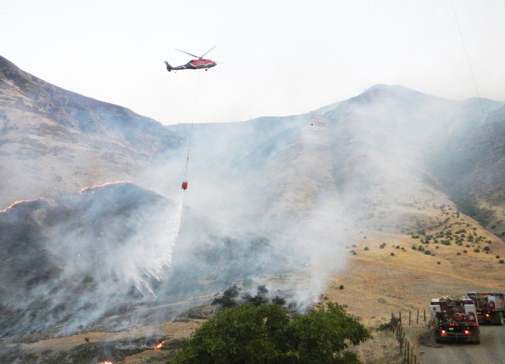
- <p>A water drop over the Wallowa County portion of the Cache Creek Fire, which had burned 63,300 acres by Tuesday morning. The fire is now projected to be fully contained by midnight on Wednesday, Sept. 5.</p>
The fight on the Cache Creek Fire lines continues this week as it grew to 63,000 acres as of Tuesday morning, Aug. 28, a little over a week after it started.
The Lower Imnaha Road/Dug Bar Road was closed by the Wallowa County Board of Commissioners Tuesday due to the fire spreading southward toward the Imnaha River.
Trending
The fire, which was started by lightning in the Hells Canyon National Recreation Area Aug. 20, was considered 40 percent contained for the third day in a row Tuesday, with an estimated containment date of midnight, next Wednesday, Sept. 5.
With an incident base at the Joseph rodeo grounds, a spike camp at Thomason Meadow and two helibases for helicopters in Wallowa County, 810 personnel plus three air tankers, nine helicopters and other resources were fighting the blaze early this week.
According to Oregon Department Forestry, 3,200 acres of the fire are in ODF-protected private land.
The next few days will be pivotal. We need to put a solid black line around the fire, said fire informational officer Alexis West at the Joseph base Monday afternoon. Fires have a mind of their own, she said, noting that rugged terrain and weather are major factors in the ongoing fight.
Periodic gusty winds have sometimes impeded the firefighting effort. Tuesday morning the incident team reported Efforts to establish containment lines were challenged Monday when winds and fuels aligned, causing the fire to push upslope near the Snake River.
The combination of topography and winds forecast for Wednesday was expected to create further problems.
Trending
Gusty, erratic winds, isolated thunder storms with outflow potential of up to 45 mph are expected Wednesday, the incident team reported.
The Wallowa-Whitman National Forest has implemented an area closure in the interest of public safety, and a partial closure of Forest Service Road, Welamotkin Road, north from the Thomason Meadow Guard Station.
Tuesday morning county commissioners issued an order to close Dug Bar Road, beginning at Fence Creek, six miles north of Imnaha, north to the Dug Bar landing on the Snake River.
In the days after being ignited by lightning late Monday afternoon, Aug. 20, just south of the historic Cache Creek ranch in the northeast corner of Wallowa County, the fire burning mostly grass in very rugged terrain quickly spread into Asotin County to near Rogersburg.
As of Aug. 23, when the fire was at 19,000 acres, the fire boundaries were reported as the Snake River on the east; the Grande Ronde River on the north; Cold Springs Ridge/Road 4680 on the west; and Cherry Creek on the south.
By Tuesday, Aug. 28, the northern part of the fire part of the fire in Washington was in the patrol and mop up mode, and resources from a spike camp there were being moved from Thomason Meadow.
However, Monday on the west and southwest perimeter, crews continued to burnout along FS Road 46 working, towards Buckhorn. On the south perimeter, a burnout operation continued down Cemetery Ridge to tie in where the main fire met the dozer line.
As of press time the fire continued its spread southward, with crews continuing burnout operations and aerial assaults to try to box in the fire.
A map and description of the closure can be found at http://www.fs.usda.gov/wallowa-whitman or www.inciweb.org/incident/3202, where regular updates on the fire are available. Updates are also posted regularly on the Wallowa County Chieftain website (wallowa.com).
Marketplace


-
eEdition

-

-
