IMNAHA?CANYON
Published 5:00 pm Sunday, May 3, 2009
- IMNAHA?CANYON
Imnaha Canyon may be only 30 miles east of Joseph, but that short drive will transport you millions of years back in time. And, that is the beauty of the canyon, which is so primitive, rugged and steep it has managed to remain as wild as the day it was born.
The Imnaha River bubbles up from under Hawkins Pass about 8,000 feet up the flank of Eagle Cap peak in the Wallowa Mountains – and in 77 miles, it drops all the way down to 3,000 feet where it joins the Snake River. The fault-line followed by the river is mostly on public land and accessible via the Hell’s Canyon National Recreation Area, the Eagle Cap Wilderness and the Hells Canyon Scenic Byway.
The geological factors that shaped the canyon make for stunning views, challenging hikes and bike journeys, and amazing exploration. The canyon also supports hundreds of deer, elk and other wildlife – including rattlesnakes. (Do not bypass this amazing canyon for fear of the snakes; just take along a walking stick and exercise reasonable caution.)
More exotic animals may be spotted with some luck. The entire area is home to cougars and, just a little north in the Chesnimnus area, you may see mountain goat or bighorn sheep. There have also been unconfirmed black wolf sightings in the Imnaha Canyon area.
You can suit up for exploration of the canyon in whatever your favorite hiking gear may be. The canyon is popular among outdoors people of every discipline – from river rafters and kayakers to equestrians, bicyclists and hikers. You may even see llama and goat packers in these hills, and you will almost certainly see nationally competitive photographers.
Forest Service trails – some cut out of sheer rock face – traverse the steep hillsides sporting names like Cow Creek Trail, Imnaha River Trail, Nee-Mee-Poo National Historic Trail, the Saddle Creek Trail, Snake River Trail and more.
The serious sightseer should not miss the climb to the lookout at Hat Point – so named because a cowboy lost his hat in the area after a battle with an unruly horse. Hat Point sits nearly 7,000 feet up on the west edge of Hells Canyon overlooking the deepest gorge in North America.
You can drive the 24 miles all the way up to Hat Point from Imnaha – but plan a half-day trip, because it will take you up to three hours to traverse the road. The trek, however, is worth it. The view of Hells Canyon and the surrounding peaks is something you’ll remember for a lifetime.
Hikers will also enjoy the five-mile hike along the lower Imnaha River to historic Eureka Bar, site of a former mining camp along the Snake River (and quite a big deal 100 years ago). While that hike is not too difficult, prepare for some short, sharp inclines along the route.
The best news for hikers is that wilderness activity of choice is possible in the Canyon nearly year-round, as the area enjoys its own microclimate and blooms early and late. While gardeners in nearby Joseph can only dream of raising their own tomatoes and melons, gardeners in the canyon pick fruit as warm-weather worshipping as peaches.
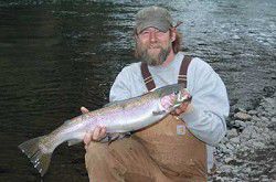
The Canyon sings a siren song to water lovers, too. The river is sufficient for rafting and kayaking year-round and challenging in the spring. A section of the river has received an American Whitewater classification of Class III-IV, so be sure to know your river before you put in. Floaters can expect to negotiate some logs placed in the river by Forest Service to create fish habitat and also may have to negotiate a fisherman or two along the route. Anglers are free to wade out into the water looking for the flash of Dollyvarden trout (catch and release only) year round. Fishermen may also try their cast at steelhead (again, catch and release only during the season).
If you are the sort of fisherfolk who wants to see trout in a fry-pan, then April through July is your time. The Rainbow on the Imnaha average between 14 and 16 inches – with a few lunkers coming in at 20 inches. Good bass, steelhead, sturgeon and cat fishing are just an hour a way on the Snake River.